
(The Mog Nation Wiki, an archive)
Nantha Kyun is an island off the coast of Arakan.

| Total Area | 2.3 km2 (0.9 sq mi) |
|---|---|
| Elevation | 168 m (551 ft) |
Geography
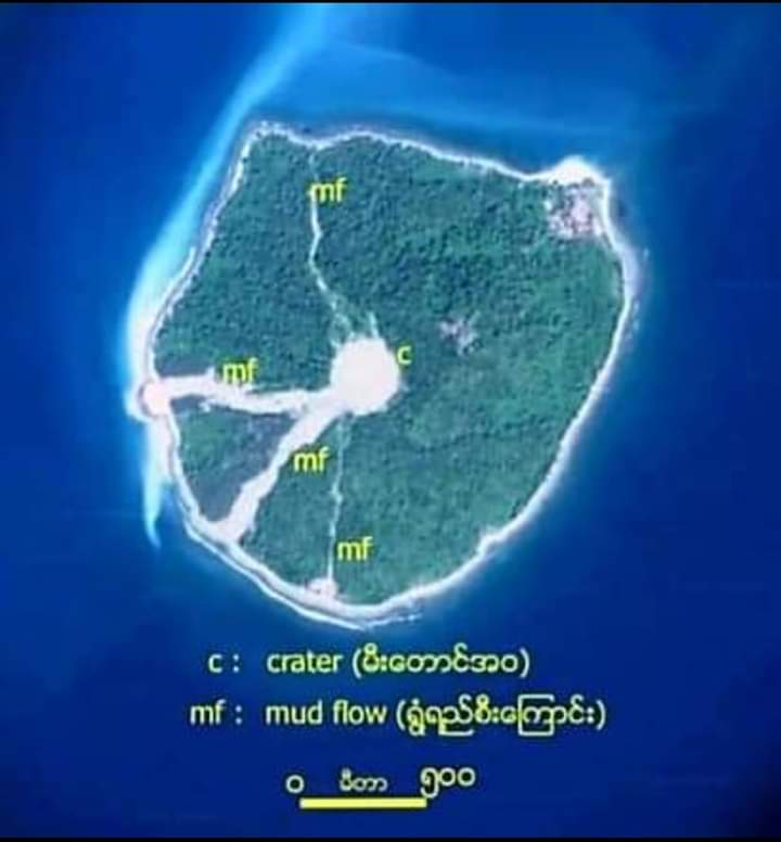
The island is 2.4 kilometres (1.5 mi) long and 1.7 kilometres (1.1 mi) wide. It is located roughly 30 km (19 mi) to the southwest of the Maw Yon headland in the Rakhine coast.[1]
Nantha Kyun rises to a height of 168 metres (551 ft) and has a large active mud volcano in the middle. It is thickly wooded except on its western shores where the terrain is scarred between the crater and the shoreline.[2]
Nearby islands
- Unguan, located about 45 kilometres (28 mi) to the NNE. Highest point 40 metres (130 ft).


End Notes and External links
- Nantha Kyun | Wikipedia
- photos on Facebook | by Soe Htut
- နံ့သာကျွန်း | The Mog Nation Wiki
- Last updated on 24th March 2022
“ကျွန်းနံ့သာအဏ္ဏဝါအမျိုးသားဥယျာဉ်” အဖြစ် ရည်ရွယ်ကြောင်း ကြေငြာစာ
ဂွမြို့နယ် ဒေသဆိုင်ရာ အချက်အလက်များ၊ ၂၀၁၉
၂၀၁၄ သန်းခေါင်စာရင်း၊ ဂွမြို့နယ်
ဂွမြို့နယ် ကျေးရွာများပြ မြေပုံ (Map_ villages of Gwa township_ 2020)
Census 2014, Gwa Township Report
၂၀၁၄ သန်းခေါင်စာရင်း၊ ကျိန္တလီမြို့နယ်ခွဲ
Census 2014, Kyeintali Sub-Township Report
The Mog Nation Wiki
Kyaw Zaw Oo
- Kyaw Zaw Oo’s Blog
- Kyaw Zaw Oo | Facebook
- ကျော်ဇောဦး | Facebook
- Kyaw Zaw Oo | Twitter
